Buckle up and take a look at these perplexing old maps of the world. Here are maps made by the Greeks more than 2,000 years ago, the first map that depicts the New World, the first one that uses the name ‘America,’ one of the first to show Australia… Oh! and a map of Virginia drawn by Pocahontas’ friend, Captain John Smith.
These 37 old maps will blow your mind:
1. Anaximander, Greek. 6th century BC

(Photo: Bibi Saint-Pol/Public domain)
This is how the Ancient Greeks viewed the world for centuries.
2. Hecataeus, Greek. 5th century BC
(Photo: Bibi Saint-Pol/Public domain)
Then someone realized the three landmasses were connected. Bravo!
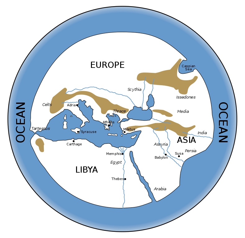
3. Eratosthenes, Greek. 3rd century BC

In high resolution. (Photo: Edward Bunbury/Public domain)
The islands of Britain and Ireland now appear on the far left.
Due to Alexander the Great’s conquests in Asia, much has been learned about the geography of that continent.
In ‘Libya’ (Africa), the powerful kingdoms of Carthage, Egypt, and Nubia are labelled.
Read next: 4 Cool, Ancient African Kingdoms That Will Surprise You
4. Pomponius Mela, Roman. 43 BC

In high resolution. (Photo: Konrad Miller/Public domain)
The Romans have been conquering their neighbors and naming the coasts of the Mediterranean.
In Europe, they have named Hispania (Spain), Gallia (France and surrounding countries), Germania, and Italy.
On the map, Asia has many more names too, like Syria and Armenia.
And the Romans have begun calling the third continent ‘Africa,’ instead of ‘Lybia.’
Check out next: 36 Captivating Paintings From Pompeii
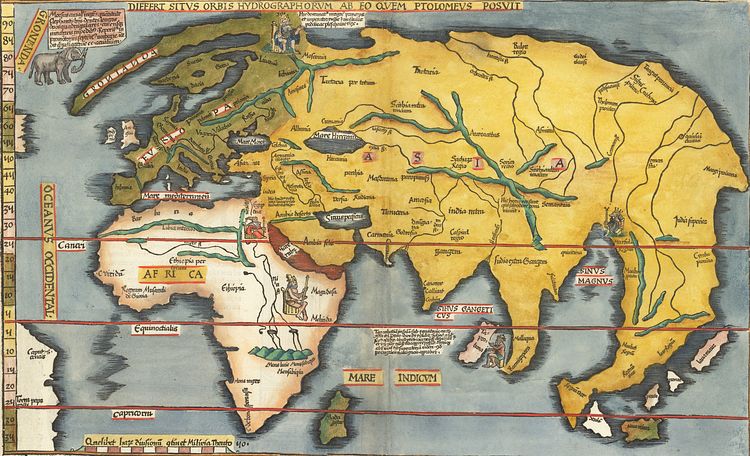
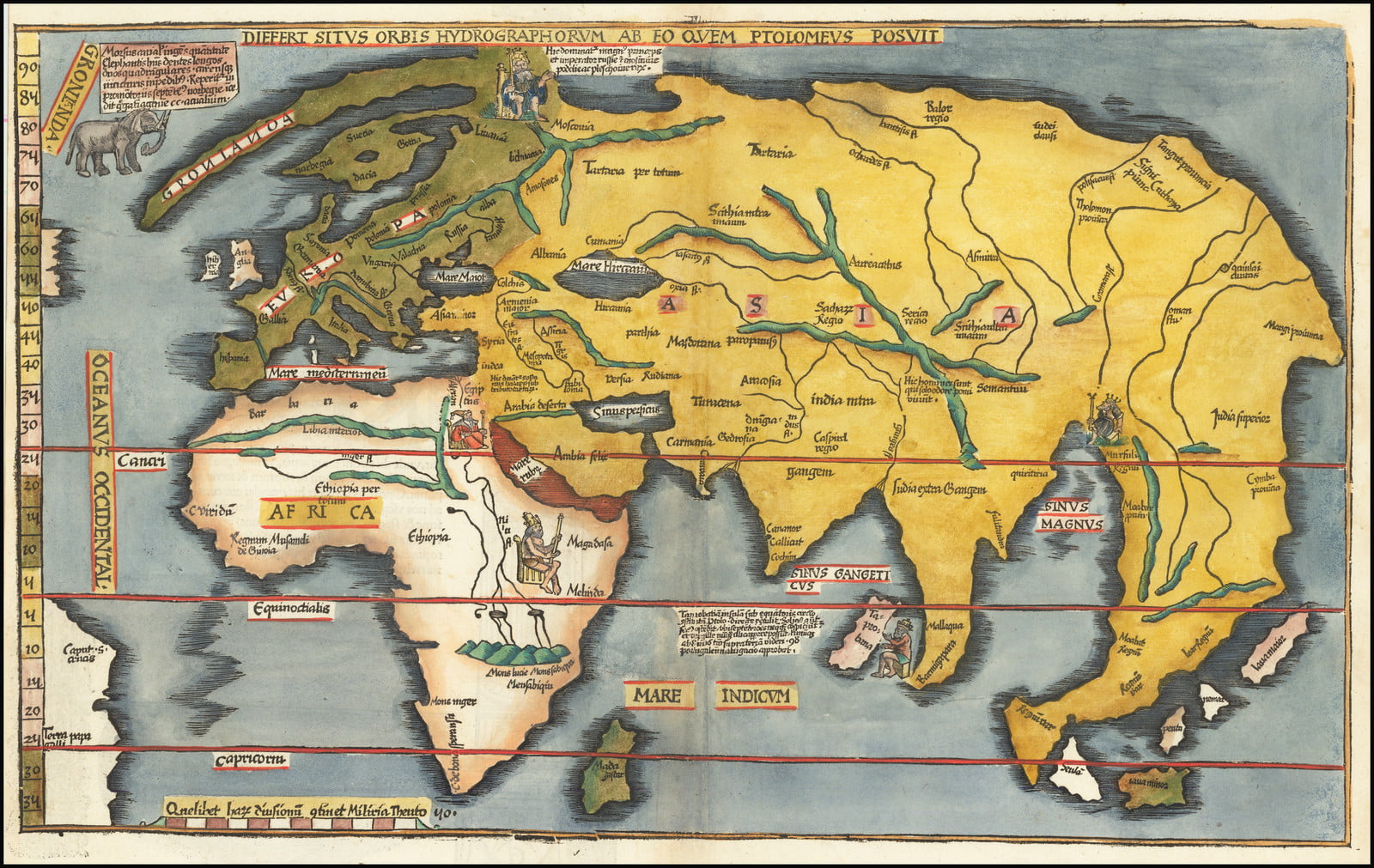
5. Ptolemy, Greek. AD 150

In high resolution. (Photo: Margaret Bertha Synge/Public domain)
Ptolemy divides Libya (Africa) into three regions.
The unnamed upper one corresponds to North Africa and includes countries well-known to the Europeans, like Egypt.
The second division is called ‘Libia Interior,’
and the third, ‘Ethiopia Interior.’
‘Ethiopia,’ in Greek, simply means something like ‘land of the blacks.’ It is the generic name that Greeks and Romans gave to the unknown territories south of the Sahara.
Read also: Here is What Happened to Cleopatra’s 4 Children- And It Is Sad
6. St. Isidore of Seville, Spain. 12th century
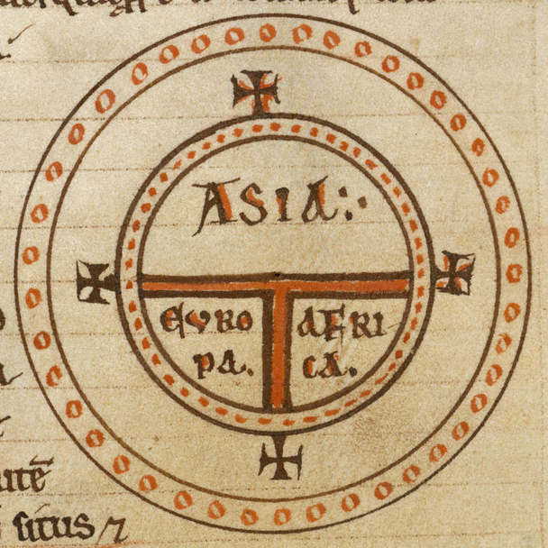
The east is on top. (Photo: St. Isidore/Public domain)
A religious world map.
It divides the world into Asia, Europe, and Africa.
Jerusalem is at the center. The Garden of Eden is in far Asia -near the top cross-, and the Pillars of Hercules (Strait of Gibraltar) are on the opposite side, near the lower cross, between Europe and Africa.
Variations of this map, called a ‘Diagrammatic T-O world map,’ were popular during the Middle Ages.
7. Al Idrissi, Moroccan. 1154

The map is called Tabula Rogeriana. In high resolution. (Photo: Konrad Miller/CCBYSA4.0)
The geographer who made this map was African, so Africa appears on top.
This map was the most advanced of its time.
8. Fra Mauro, Italian. 1459

Africa is on top again.
The map has many details such as rivers and city names.
Also, northern Europe is now drawn in, and Africa is getting bigger.
9. Henricus Martellus, German. 1490

In high resolution. (Photo: Henricus Martellus/Public domain)
There are two tails here. One is on the top of Europe and probably represents the Nordic countries.
The other is on the right of the map, in Asia, and goes down into the ocean.
This is the first map that includes this ‘Asian dragon tail.’
And although this tail does not exist, it will keep showing up in the maps for the next 30 years or so.
10. Juan de la Cosa, Spanish. 1500
In high resolution. (Photo: Kimon Berlin/Public domain)
The New World has been discovered!
It is that green, oversized landmass on top.
This is the oldest surviving map that shows the New World.
The map has the west on top, so Europe, Asia, and Africa are on the bottom. If you look carefully, you can make out their faded outlines. Africa’s shape is quite accurate thanks to the recent discoveries of Portuguese explorers.
In the New World, the green landmass on the left is upper South America (Colombia, Venezuela, and Brazil). The right landmass is probably North America (Canada).
Between them are two smaller islands: Hispaniola and the other might be Cuba. Those islands were among the first territories explored and settled by Christopher Columbus.
The man who drew this map, Juan de la Cosa, sailed with Columbus in his first two, perhaps three, trips to the New World. Juan would make seven trips in total. He explored Cuba and the northern coast of South America. Juan believed Cuba was an island while Columbus thought it was Asia.
These early maps were a secret closely guarded by Spain, the country that had financed these voyages. Spain didn’t want competition in its newly discovered territories, aka the New World. (More on this map)
Want to Know Which Are the 8 Oldest Cities in the Americas? Here They Are!
11. Portuguese map. 1502

This top secret map was stolen and smuggled out of Portugal.
The map emphasizes the territories explored by Portugal. The coast of Africa is accurate and includes recently discovered Madagascar (that island next to the bottom right of Africa).
In the New World, the coast of present-day Brazil is mapped out (bottom left), along with the Caribbean islands.
That green, small landmass above the islands (far left) is likely Cuba, or perhaps Canada, since Florida had not been explored yet.
The green line that goes top to bottom and divides Brazil marks a treaty between Portugal and Spain.
The two superpowers had been exploring the world, and so they wouldn’t clash claiming lands, they signed this treaty in 1494.
It stated that anything discovered west of that line belonged to Spain, and anything discovered east of it, to Portugal.
It was a gamble. Nobody was sure what their explorers would find west or east of the line.
Spain won the gamble: the Americas were west of the line!
That is why they belonged to Spain.
12. Johannes Ruysch, Dutch. 1507
When Columbus disembarked in the New World, he thought he was in Asia. The confusion lasted decades.
Here, Asia is on top.
On the right, it is connected with Europe and Africa, as one would expect.
But on the left, it is connected with the recently discovered territories of North America.
Meanwhile, South America is that big disconnected mass on the bottom left. And it alone is labeled ‘New World.’
13. Martin Waldseemuller, German. 1507
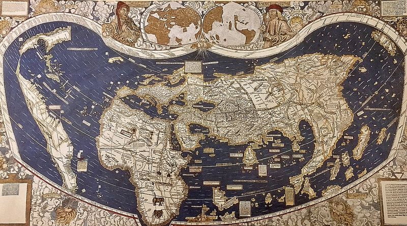
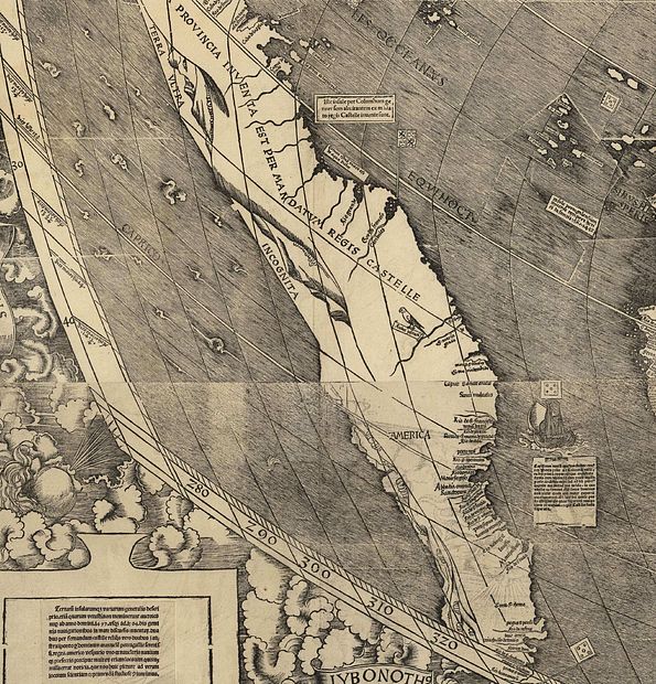
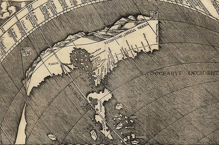
In high resolution. (Photo: Martin Walseemuller/Public domain)
This is the first time the name ‘America’ appears on a map.
Spain had financed Columbus’ trips to the New World. But a few years later, Spain and Columbus were not seeing eye to eye.
So the crown dispatched Italian explorer Amerigo Vespucci to the new lands.
Amerigo explored eastern South America and determined it was not Asia, as Columbus believed, but a new continent.
Far away in Germany, mapmaker Waldseemuller read Vespucci’s account.
So, on this map, Waldseemuller draws the New World as a separate continent and names it ‘America’ in honor of Vespucci. He places the name in South America, in present-day Brazil.
The largest island north of South America -the one that a modern eye could confuse with North America- is likely Cuba (labeled Parias).
Waldseemuller calls it ‘Cuba’ on a later map.
14. Lopo Homem-Reineis, Portugal. 1519

And back to the idea that all the world’s landmasses are connected.
The name ‘Brazil’ is already in use for what is indeed present-day Brazil.

Another map from the same Miller atlas just seen above.
Europe and Africa are on the right, with some interesting drawings. The New World is on the left.
Four red banners label the Americas. The one on the upper left, where the bears are roaming, is called Terra Binenes, aka Florida. The Spaniard Juan Ponce de Leon has just been exploring it.
The second banner reads Ante Yillas, so it is referring to the islands. Beneath it, Natives are depicted doing their thing in Central America. The words in South America’s banner have faded.
And the fourth banner is on the center top of the map and it shows Greenland or Canada. It is labeled ‘Corte Regalis Lands’ after the Portuguese captain that explored those territories, Gaspar Corte Real.
In another map that appears in this same atlas, there is a legend warning prospective tourists that the Natives of Brazil are ‘wild and very cruel.’
Don’t miss: How Many Continents Are There, Really: 5, 6, 7…? Was your teacher wrong?
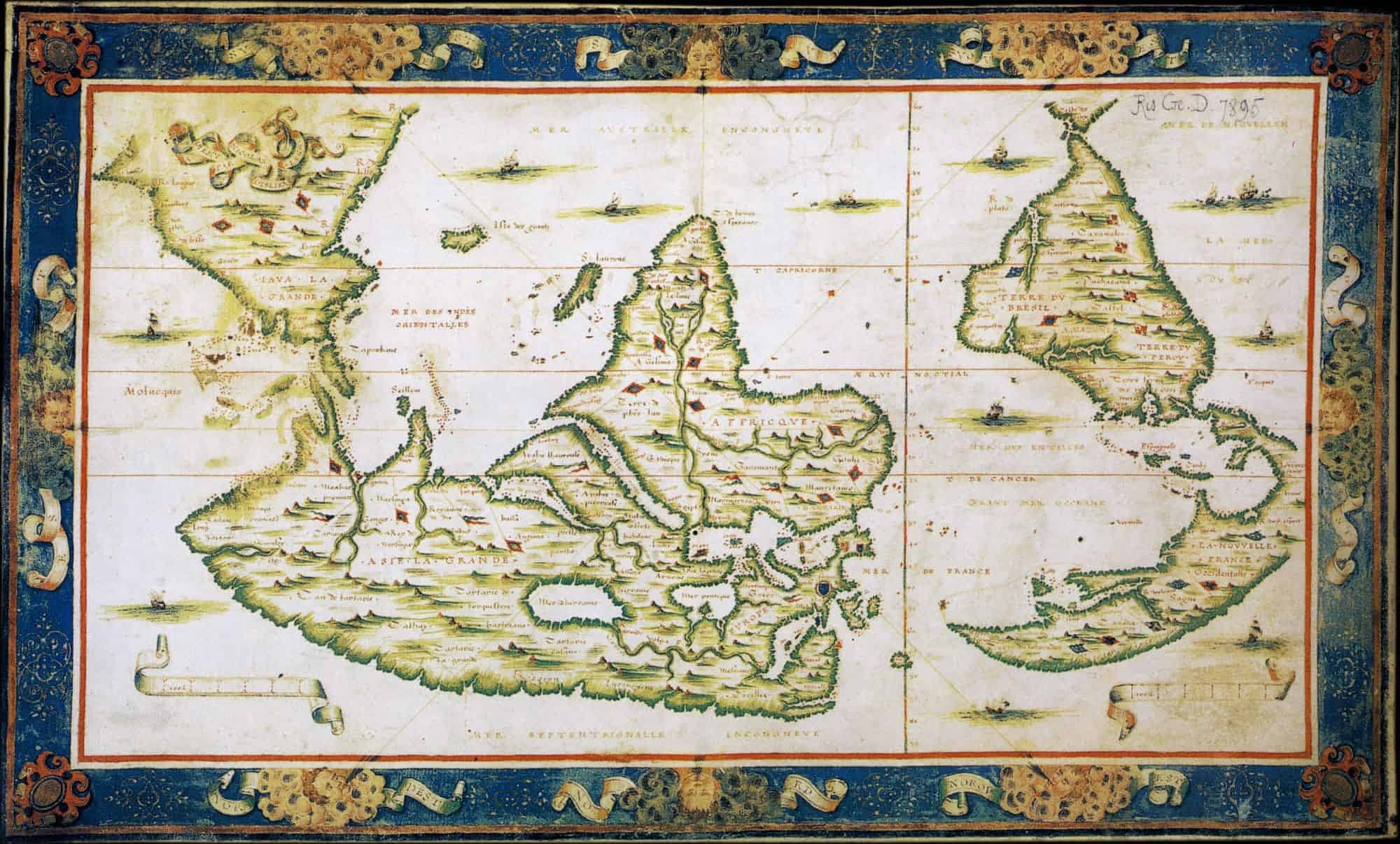
15. Johannes Schoner, German. 1520
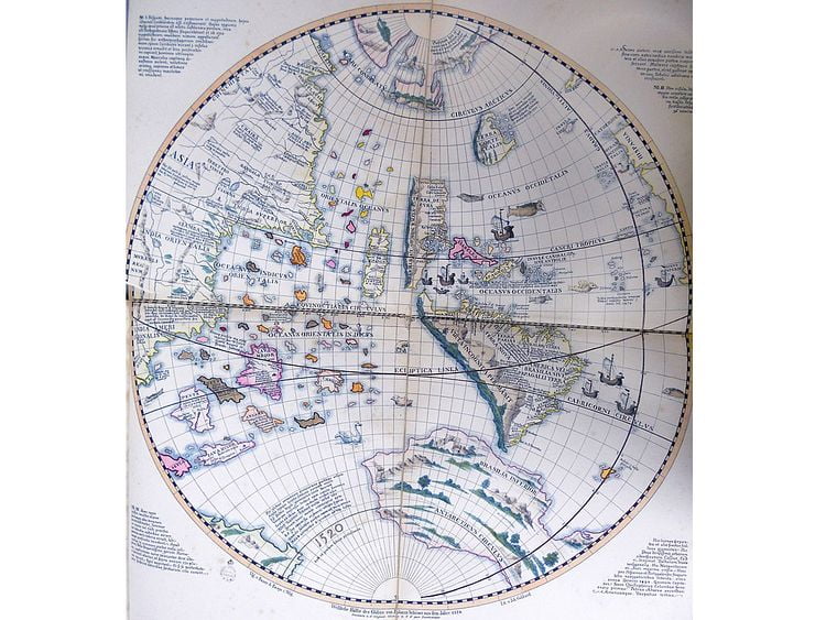
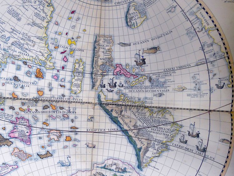
In high resolution. (Photo: Johannes Schoner/Public domain)
A view from the Pacific Ocean.
Asia’s geography (the landmass on the left) is all over the place. Its eastern coast ends with ‘India.’ There are also references to Tibet and Ciamba (Vietnam).
The big, pink island off the coast of Asia is Java Major.
Marco Polo mentions it, and it appears on many maps, but no one knows for sure which modern island it is.
Further south is Java Minor which is modern Sumatra.
The yellow, big island in the center of the map, labeled Zipangri, is Japan.
Mapmaker Schoner thought America was a continent made up of islands.
So here, America is composed of those big islands with blue stripes located at the center of the map.
The largest island is South America, which is labeled ‘America or Brazil or Land of the Parrots.’
The second-largest island, to the north, is labeled ‘Land of Cuba.’
And the other Caribbean islands are grouped under ‘Islands of Cannibals or Antilles.’
The blue-stripped island on top is northern North America. Once more it is labeled ‘Land of Corte Realis,’ after the Portuguese explorer.
Below South America is yet another island. This one is branded ‘Lower Brazil,’ and is probably the southern part of South America.
16. Laurent Fries, French. 1522

In high resolution. (Photo: Laurent Fries/Public domain)
One of the last maps showing the ‘Asian Dragon Tail.’
The other tail, above Scandinavia in Europe, has been labeled Greenland. But, spoiler alert, in reality Greenland is an island.
17. Map made in Germany. 1524
This is a Native-American city.
The Europeans discovered it in 1519.
It was called Tenochtitlan and housed 200,000 people or more.
The impressed Spaniards made maps of the city and wrote about it. But their relations with the locals soon deteriorated, and the Spaniards destroyed Tenochtitlan in 1521.
On top of the ashes, they founded Mexico City.
The maps depicting Tenochtitlan survived, and this one was published in Germany in 1524.
The ‘lagoon’ on the left is actually the Gulf of Mexico and shows Yucatan, Cuba, and the southern part of the US, including Florida.
18. Franciscus Monachus, Belgian. 1527
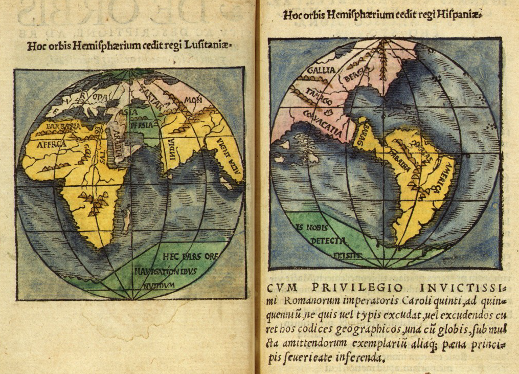
In this map, South America is connected to Eurasia!
South America is on the right, in yellow. It is labeled ‘America.’
On the north, it is almost joined with a pink landmass that instead of being North America is Eurasia.
The right map is titled ‘The hemisphere ruled by Spain,’ while the left map reads ‘The hemisphere ruled by Portugal.’
It refers to the treaty between Spain and Portugal mentioned above.
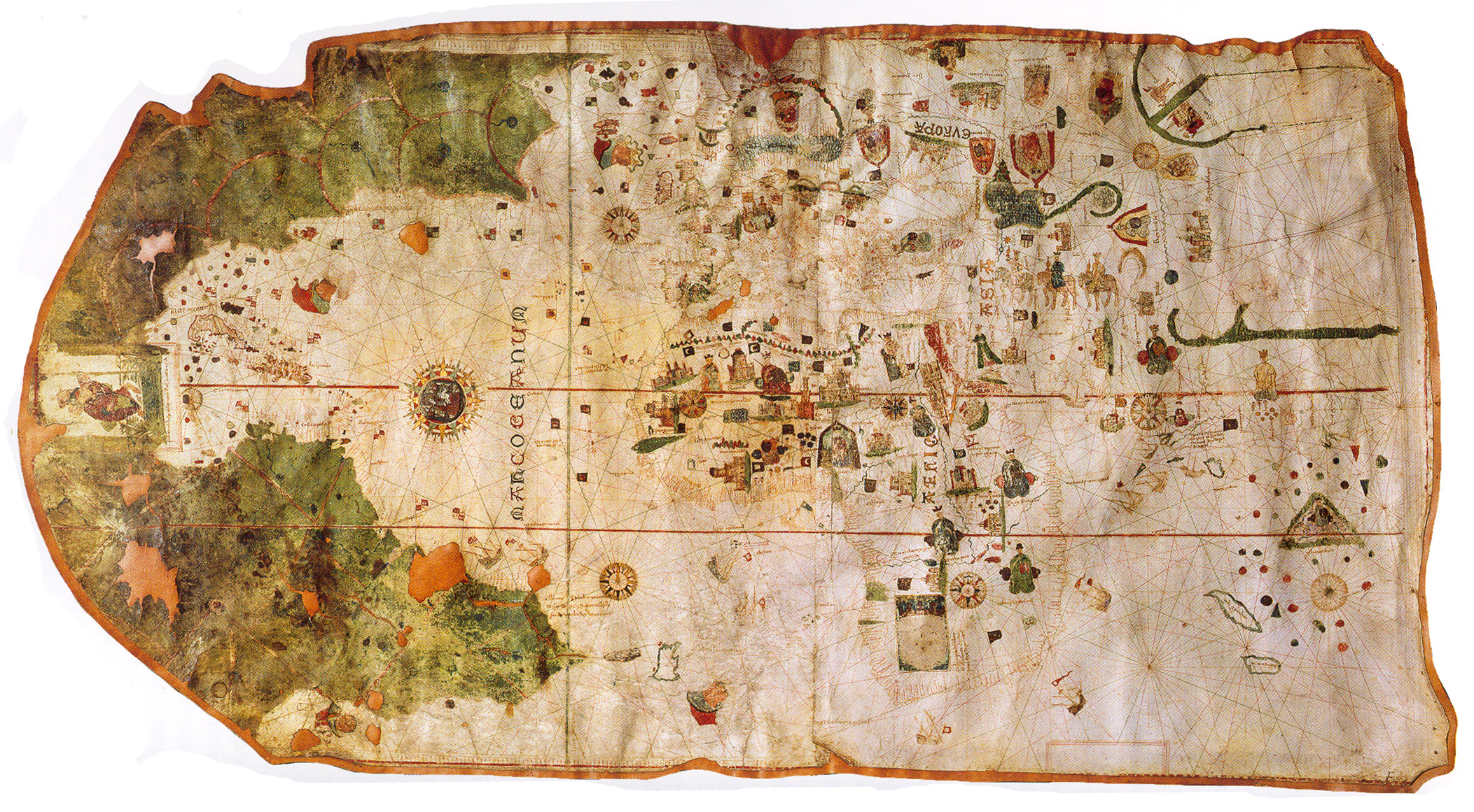
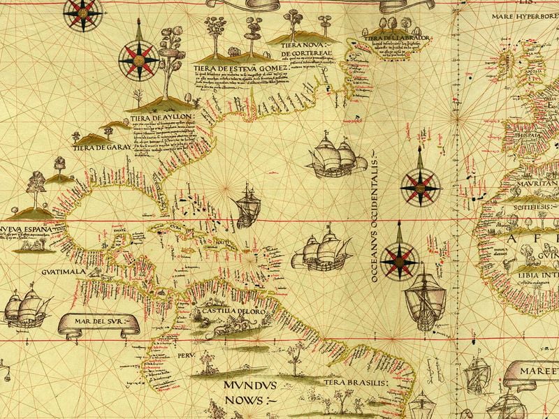
19. Diego Ribero, Portuguese working for Spain. 1529
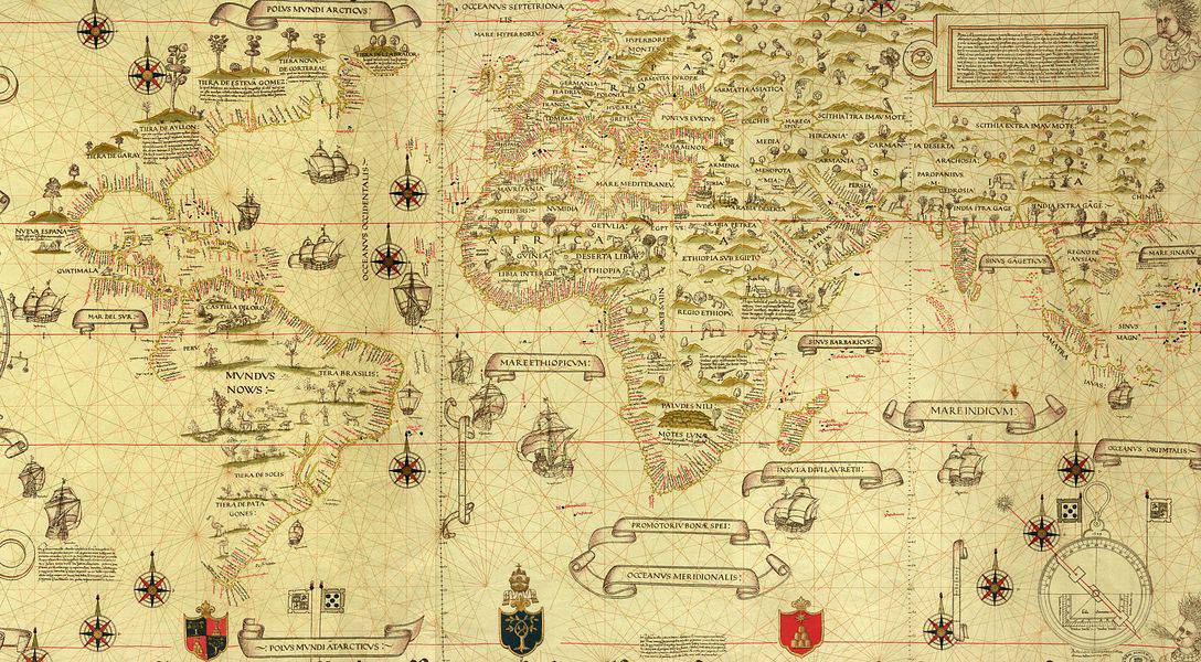
In high resolution. (Photo: National Library of Australia/Public domain)
The Spanish have been busy in the New World. They have named all the eastern coast, from Canada to the tip of South America.
They have also established several colonies, including the first European colony in the US.
That colony is labeled ‘Aylon’s Land’ (Tierra de Aylon) in honor of its founder, but the colony’s real name was San Miguel de Guadalupe.
It was established in 1526 in what now is South Carolina.
Other places in North America are labeled ‘Lands of Garay’, ‘Lands of Esteva Gomez,’ and ‘Land of Labrador‘ after the Spanish and Portuguese captains that explored them.
The Spanish were still being ultra-secretive with their maps.
The men that returned from the Americas had to relate their discoveries to the authorities. The information was added to a master map called Padron Real.
Revealing the Padron’s contents to unauthorized personnel was punishable by death.
So the maps of other countries won’t have this degree of accuracy about the geography of the Americas in decades -or in some cases centuries- to come.
Europe and Africa are perfectly drawn in, with Asia still needing a bit of work. All are labeled with fascinating names.
The proportions on this map are also surprisingly accurate -this is before the wonky Mercator Projection began beeing used. So Europe is, correctly, shown much smaller than Africa and Asia.
20. Oronce Fine, French. 1536
South America, labeled ‘America,’ connects with North America/Asia.
21. Sebastian Munster, German. 1545

This is the first map to use the name ‘Pacific Ocean.’ Ferdinand Magellan named this ocean after sailing across it in 1520.
As a novelty, North America has been split into three: Florida, New France, and Terra Nova.
Florida was explored and settled by the Spanish; hence the name that, in Spanish, means something like ‘Land in Bloom.’
New France (eastern Canada) was settled, as one would guess, by the French.
And ‘Terra Nova’ is Newfoundland, in Canada. It was first sighted by John Cabot, an Italian explorer who worked for the English crown.
22. Giacomo Gastaldi, Italian. 1548

23. Peter Apian, German. 1553
24. Diego Gutierrez, Spanish. 1562

By now, the Spaniards have explored nearly all the coasts of the Americas. They still have to visit the western coast of North America, though.
They know California as a peninsula and is shown as such in this map. Yet, in many other maps, California will appear as an island for almost 200 years.
Also of notice is that the name ‘Canada’ is already in use. The French explorer Jacques Cartier coined it.
Don’t miss > Simon Bolivar in 15 Facts: The South American Who Brought Down the Spanish Empire
25. Nicolas Desliens, French. 1566
The south is on top.
The big landmass on the upper left is Java Mayor, again. That is the big island that Marco Polo wrote about. Some think it may be Australia, which was officially discovered decades later.
France’s territories in North America (bottom right) are labeled ‘New France’ (La Nouvelle France).
26. Abraham Ortelius, Belgian. 1570
In high resolution. (Photo: The Library of Congress/Public domain)
Welcome aboard, Papua New Guinea!
There it is, the big, green island on the far left. It was discovered by Spanish and Portuguese sailors in the 1540s but kept being ignored in the maps.
The New World is labeled ‘America or New India.’
The large landmass on the south is labeled ‘Unknown Southern Land‘ (Terra Australis Nondum Cognita).
The ancient Greeks had noticed that the known continents (Africa, Europe, Asia) were all on the north, so they predicted there would be a landmass on the south balancing things out. The Greeks liked balance.
So some cartographers, like Ortelius, drew in this theoretical landmass.
In 1820, Greeks and cartographers were proven right when Antarctica was discovered.
27. Heinrich Bunting, German. 1581

28. Abraham Ortelius, Belgian. 1586

The Pacific Ocean with its recently explored islands.
The Spanish have now explored most of the New World’s coasts. That includes the western coast of North America, which they have now named.
29. Petrus Plancius, Dutch. 1594
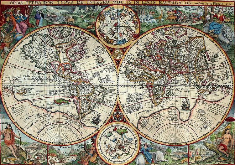
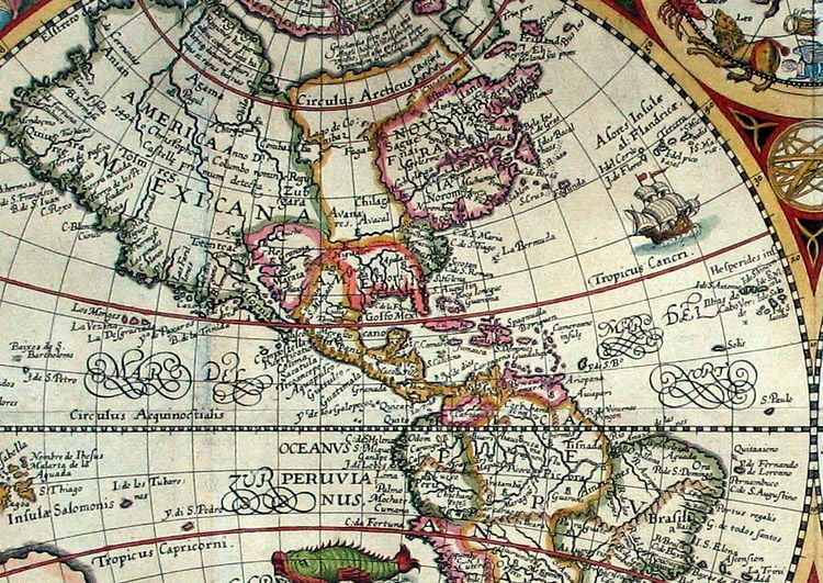
In high resolution. (Photo: Petrus Plancius/Public domain)
A plot twist.
North America is labeled ‘Mexican America,’ and South America is labeled ‘Peruvian America.’
Many maps made during those years use these names.
Also, the subregions of the Americas do not correspond with the modern ones.
Peruvian America includes most of the Americas, including Central America and part of what is now the US.
30. Theodor de Bry, Belgian. 1596

Another example of Mexican America and Peruvian America.
In other news, the English have arrived in the New World!
The English began exploring North America in earnest in the 1580s. They established settlements in Newfoundland (Canada), and Walter Raleigh claimed Virginia for England.
The label ‘Virginia’ is on the right of North America, under New France.
31. Jacob Hondius, Belgian. 1598

A close-up of northeast South America.
Mapmaker Hondius is being a pal and letting you know, in the legends, that there are cannibals in Guyana. Watch your step.
He also tells you that farther south, headless men (called Blemmyes) are roaming around.
32. Wright-Molyneux. British. 1599

This is the first modern world map created and published in Britain.
It labels the British territories of Virginia and Newfoundland in North America. And it accurately draws the coasts of Africa, Europe, and Asia.
33. Arnoldo di Arnoldi, Belgian. 1600
This map has many informative legends.
In one, it lets the reader know that Tartaria (in yellow, far right), in Asia, is governed by Christians that arrived in 1290.
In another, it describes the inhabitants of Java as short, corpulent, with long faces. And says they go naked and are inhuman and cruel.
He also says the inhabitants of South America tended to be inhuman and cruel, but adds they are better since the Spaniards converted them to Christianity.
And Arnoldi labels North America ‘Mexicana.’
Read more: 7 European Aristocrats That Ended Up As Slaves in Recent Times –One of them was a Spanish explorer enslaved by Native Americans
34. Matteo Ricci, Italian. 1602
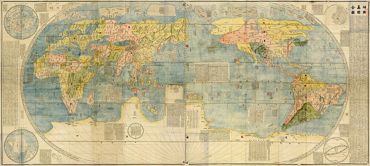
This map was made for the emperor of China. So, following Chinese tradition, China appears near the center of the map.
35. Gerardus Mercator, German. 1623

The globe seen from the Artic.
At this time, the Arctic had not been explored, so Mercator draws it based on philosophical theories.
The Arctic is in yellow, and at its center, there is a magnetic rock.
The other continents surround the Arctic. America is in green, Asia in pink, Europe is multicolor.
(More on this map)
36. John Smith, British. 1627
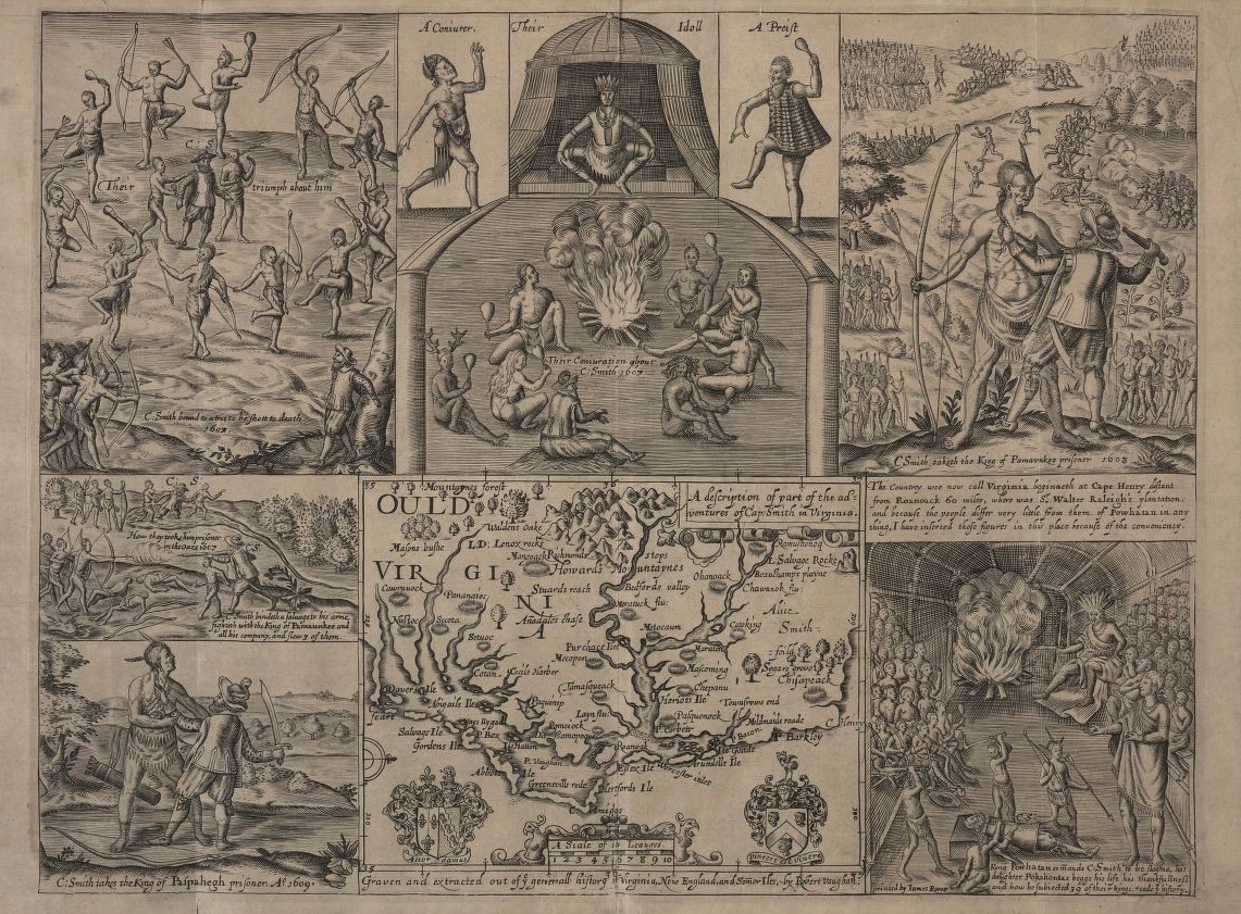
Captain John Smith -as in Pocahontas’ John Smith- made this map and drawings.
Smith helped establish the colony of Jamestown, in Virginia, in 1607.
It was the first lasting English colony in what is now the US. The colony would suffer several setbacks and finally be abandoned 92 years later.
Founding Jamestown was not easy, either. Enter Smith’s engravings to prove it.
On the bottom center, Smith has placed a map of Virginia.
On the top right, Smith is captured by a Powhatan Native, who takes him to his tribe.
Then, the most famous scene takes place. On the bottom right, Smith lies on the ground surrounded by the Powhatans. He is about to be killed, but the chief’s daughter, Pocahontas, intervenes and saves him.
The other engravings show him tied to a tree with dancing Natives ready to shoot him (top left), a ceremony (top center), and Smith capturing the chief of another tribe (bottom left).
37. Henricus Hondius, Dutch. 1630
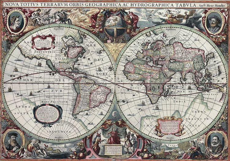
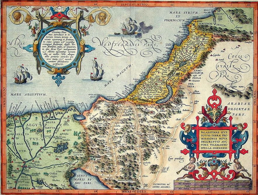
World map in high resolution. Europe in high resolution. Africa in high resolution. Palestine in high resolution.
Australia is in the house!
About time, too, since it was officially discovered in 1606 by the Dutch. They called it New Holland.
New Holland is that pink stretch at the far right of the map, under New Guinea.
Which old world map did you find most perplexing?
More Articles


