Some people say there are four continents, others swear that there are five, six, or seven. Who is right?
How many continents are there, really?

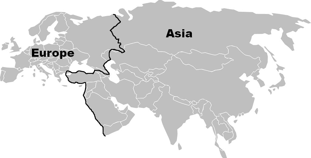
Fun experiment: How many continuous landmasses do you see?
(Image: Strebe/Public domain)
On paper, the question about the continents seems simple. A continent is a large landmass surrounded by water, so it is like a huge island.
Thus, if you were to pick up a world map and count the huge landmasses, you should have your answer. Right? Wrong.
Try it with the map above. This may raise more questions than it will answer: Wait, the Americas look like one continent, weren’t they supposed to be two? Europe and Asia look like one huge continent too!? Is Africa part of Asia…?
Worry not. Nobody has got a straight answer to this question. If you ask geographers, they will admit that it all comes down to convention.
They will also probably tell you that ‘continent’ is not a scientific term. So there are no strict criteria for defining a continent.
A continent does not have to have a minimum size or be a certain distance from other landmasses. Australia, for example, was for ages considered an island; only recently it got upgraded to ‘continent.’
How one divides the continents boils down more to history and culture than to undisputed scientific facts. (If you are thinking: “No way, what about the tectonic plates?” Read below)
Continental Europeans count different continents than their UK peers
If you went to school in the UK, the US, or other English-speaking countries after 1960, you were probably taught that there are 7 continents.
But if you went to school in many other European, African, Asian nations, or the rest of the Americas, you may have learned that there are 6 or 5 continents.
The purists count just 4 continents. Some slim it down even more and count 3.
While others go in the opposite direction and count more than 7.
Since there are no strict criteria for defining what a continent is, all those answers are valid. It just depends on how you are counting.
These are the models with most fans nowadays:
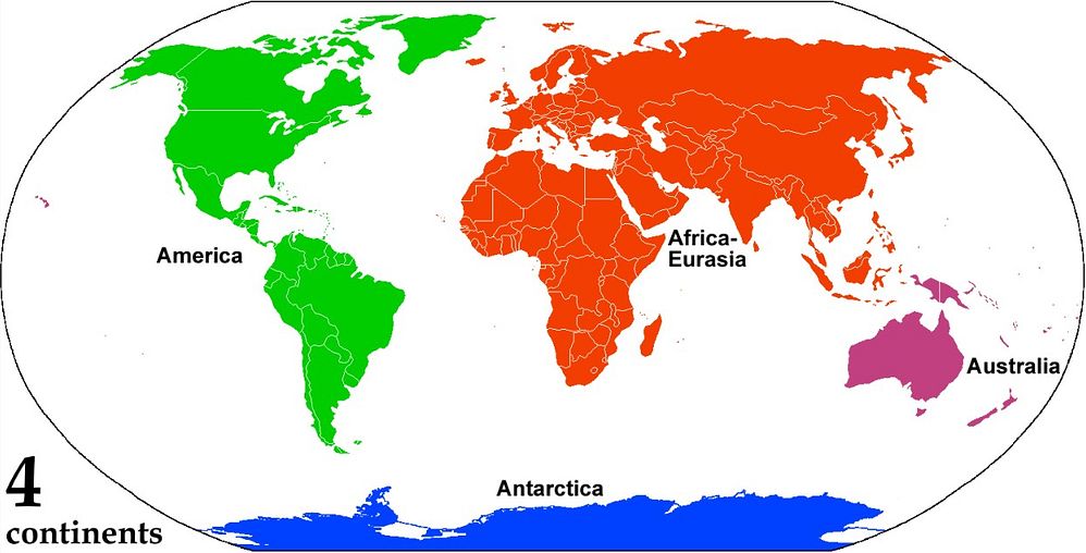
The choice of purists. It is way less popular than the others, though.
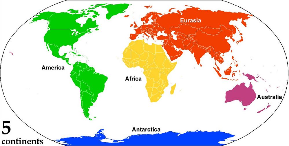
This is the predominant view in Eastern Europe, Asia, and elsewhere.
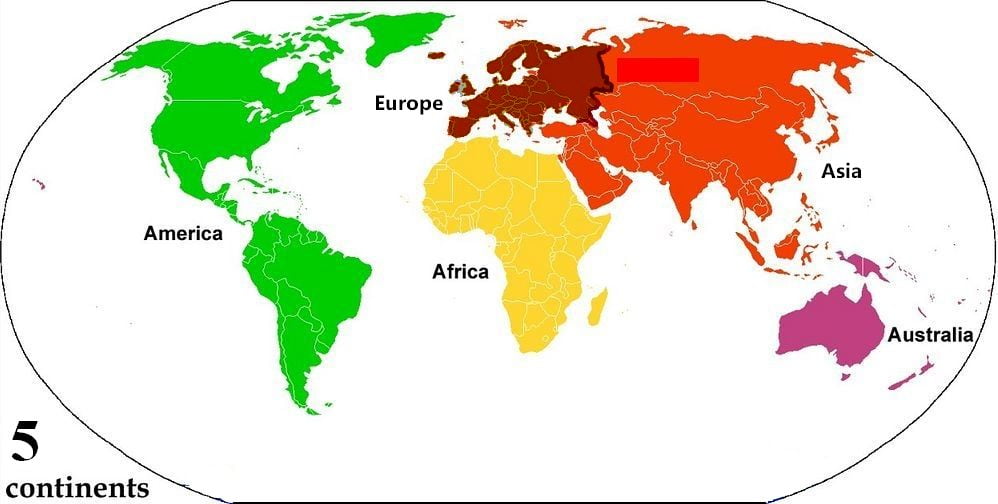
A classic. This model had a good run for most of the 20th century. It was taught in the Americas, Europe, and elsewhere.

Like the previous one, but with Antarctica on board. Most countries in the Americas, many in Western Europe and Africa divide the world like this. The United Nations also uses this model.
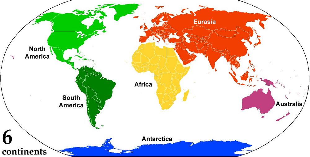
This 6-continent version may not be as diffused worldwide, but it has some die-hard fans like the Norwegians and Russians. (Russians also learn the previous model in tandem.)

The all-inclusive super-deluxe 7-continent combo. It is the version beloved in most English-speaking countries. It is also favored in some north European countries, and in some Asian countries like China and Singapore.
(Images: AlexCovarrubias and Corticopious/Public domain)
Dilemma #1: Are Europe and Asia two continents or one?

Definitely one continent. #teamEurasia (Image: Wikimedia/Public domain)
Definitely two continents. #team7continents. (Image: Harbin/Public domain)
Europe and Asia are really just one continent. Eurasia is a continuous (the word contin-ent comes from contin-uous) landmass.
But most people consider them two continents because of historical reasons.
Before 500 BC, the Greek geographers thought that Europe and Asia were separate continents. To get to Asia, the Greeks had to cross the sea. So Europe and Asia seemed like separate landmasses to them.
Furthermore, the European Greeks were constantly quarreling with the Persians from Asia. And each group thought the other dressed in a funny way and had strange traditions. So the divide between the two was not just physical, but also historical and cultural.
From 500 BC onwards, the Greeks realized that Africa, Asia, and Europe were one landmass and thus, one continent. But by then, the cultural division was already too deeply set, and they continued to consider them separate continents.
That mindset has trickled down to our days. Plenty of people still think of Europe and Asia as separate continents.
The countries that have territories in both Asia and Europe

Russia, Kazakhstan, Georgia, Azerbaijan, and Turkey have territories in both Europe and Asia. According to some divisions, so does Armenia. (Image: Wikimedia/Public domain)
Where exactly Asia ends and Europe begins has been a matter of controversy for hundreds of years. And there is still no agreement on where exactly is the border.
Whichever border you choose, some countries get caught in the crossfire. Russia, Kazakhstan, Azerbaijan, Turkey, Georgia, and sometimes Armenia, end up having territories in both Asia and Europe.
So you can be walking in the Asian side of Russia and all of a sudden find yourself in Europe.
Who prefers ‘Eurasia’ and who does not

Most geographers consider Eurasia one continent.
Unsurprisingly, those born near the border also call it Eurasia. That includes Eastern Europeans and Western Asians.
They prefer the term not only because of the pesky border itself, but also because they have deep historical and cultural ties with both sides.
It would even be odd if, say, Russia, with its history and location, thought of Eurasia as two continents. To Russians, both sides are home.
On the other hand, those who live far from the border get to philosophize about the division.
That is true for the countries located at the extremes of Eurasia -like Spain and China.
They are so distant, that they had zero interaction with each other for millennia. So each developed its own unique culture. And now the culture of the other seems strange.
So they readily think of Europe and Asia as different entities. And consider those on the other side of the border as foreigners. Us vs. them.
This view prevails in some Asian countries and in Western Europe. Also in places influenced by Greek thought, such as the Americas and Africa.
More on Russia: Why Is Catherine the Great of Russia called ‘Great’? Her Accomplishments
Dilemma #2: Africa
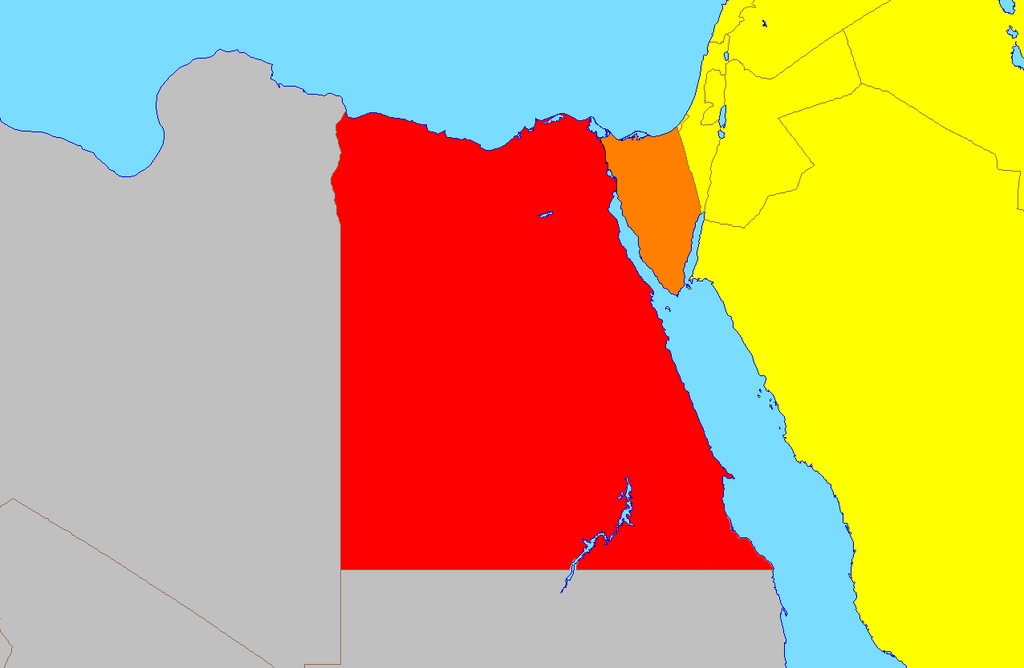
(Image: LukeSurl/CCBYSA4.0)
Up to the 18th century, and even 19th, it was usual to simplify things and say there were two continents: the Old World and the New World.
The Old World included Africa, Asia, and Europe; the New World, the Americas.
Another look at the map will show that there is sense in that.
Africa and Asia are, indeed, joined. Egypt has land in both Africa and Asia. The only separation between them is a shallow, man-made canal dug over a century ago.
So some people still consider that Africa, Europe, and Asia form one big continent called Afro-Eurasia.
Four Awesome African Kingdoms Nobody Told You About. They are ancient and from sub-Saharan Africa
Dilemma #3: America. Or is it the AmericaS?
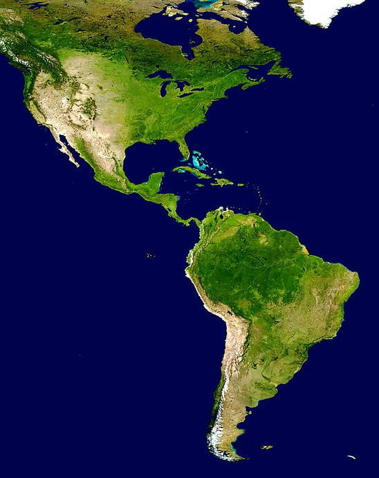
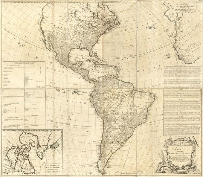
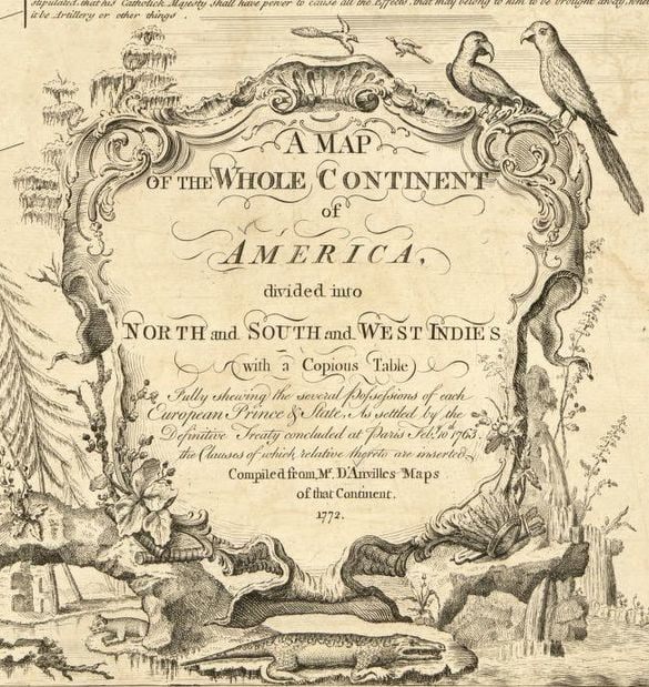
One or two, take your pick.
After the Europeans bumped into the New World, they called it ‘America.’ And, apart from some glitches here and there, that was the continent’s name for more than 400 years.
In some maps, the continent was divided into subregions: North America, South America, and usually the West Indies/Caribbean.
After World War II, the geographers in the United States thought it would be better to split ‘America’ in two. It was partly a political choice propelled by the war. Plus, at the time, it seemed to be backed up by the brand new and shiny ‘plate tectonics theory’ that was developed in those same years.
So in the 1950s, the US scholars split ‘America’ along the previous subdivisions. The Caribbean and everything north of Colombia became the continent of North America. While South America became a separate continent. And voilá, the two Americas were officially born.
Some countries adopted this ‘Americas’ concept enthusiastically, mainly other English-speaking countries like the UK and Canada.
But the innovative idea did not take everywhere.
So if you are born in most countries of Europe (like Germany, Italy, Greece, or France), Asia and the Americas, or in some of Africa, when you go to school, you will still be taught that there is only one big continent called ‘America.’
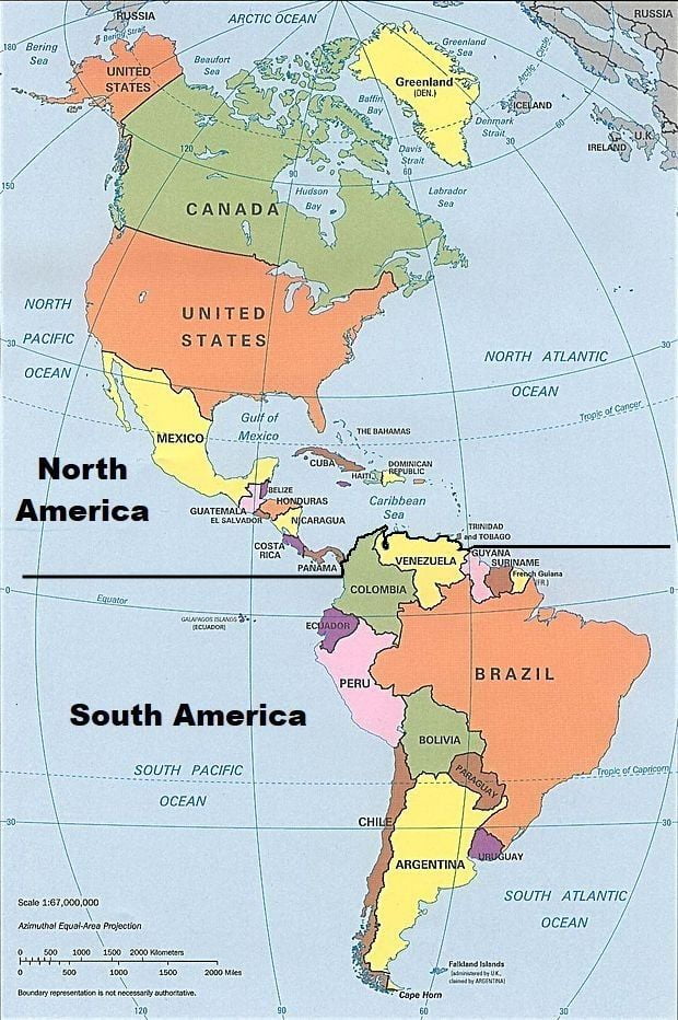
But where do they split?

Again, the splitting of the Americas is problematic.
The division is in Panama. But there is disagreement about where in Panama. Some choose the political border that separates Panama and Colombia.
That border is in the middle of the jungle. So if you were walking on the North American side of the jungle, you would not realize the moment you stepped into South America. All trees look the same.
There are issues with dividing the continents there. Thus, other people place the split in the shallow and recently man-made Panama Canal.
But if the division is at the canal, Panama is split into two. Part of the country would lie in North America and the other part in South America.
Needless to say, Panamanians are not fond of the two continents idea.
Can one walk from Argentina to Alaska?
As we have seen, walkability is not a requirement for continents.
You can walk from Asia to Europe. Yet, they are usually considered two continents.
But to answer the question: Yes. You can walk from Argentina to Alaska.
Two Americas: I hardly know you
From an Anglo-american perspective the split comes naturally.
Canada and the US have no cultural or historical ties with South America.
The US has ties with Mexico, Central America is nearby, and the US had a strong presence in Panama for decades. That is its area of influence.
South America, on the other hand, is far away. It is an unknown and unknowable culture and territory, with a language barrier.
So the Anglo-countries split the continents at Panama. Since the US has ties with Panama, that country is included on their side. While that strange land that is South America becomes another continent.
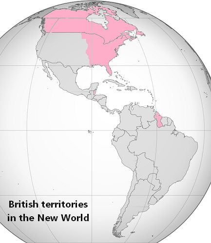
The split also makes sense in the UK. Britan had territories in North America during colonial times and only a small territory in the northern-most part of South America. So for almost 200 years, their attention was solely on the north.
Thus, they readily divide the New World in two parts: the part we settled (North America), and the part we did not settle (South America).
This model spread via the British Empire.
One America: We don’t want a divorce
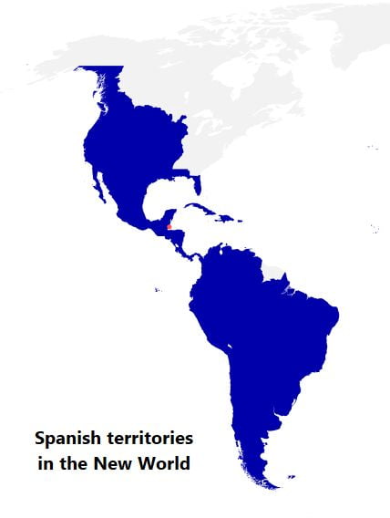
But Spain has a different perspective.
Spain colonized the New World, from south of Canada to Argentina.
So all the New World was Spain’s piggy bank for 300 years.
For 300 years the Spaniards wrote about the rebelious ‘Americans,’ meaning the modern Mexicans or Colombians. For centuries they traveled to ‘America,’ meaning Cuba or Ecuador.
The New World was one, and it was theirs. So they, and many of their European neighbors, still consider America one continent.
The same mentality goes for the countries in the Americas colonized by Spain.
These nations were part of the Spanish Empire for 300 years. So they have strong linguistic, cultural, and historical ties with each other.
Imagine someone told Canada and the US that they are no longer part of the same continent, that they are to split. “That we split from our chummy cousin with whom we have a shared history, culture, and language? That is nonsensical,” would probably be the answer.
And that is what the Spanish (and Portuguese) Americas think about the idea of two continents.
From Mexico in the north to Chile in the tip of the south, they consider themselves one big, happy family. And they have always been one, thanks for asking. No one is getting a divorce.
Furthermore, those who believe in two continents place Panama on one continent and Colombia on another. But for the countries involved, that simply won’t fly. The countries share too much history.
Panama and Colombia were one single country for more than 400 years. During colonial times, they were part of a viceroyalty along with Venezuela and Ecuador. Then, the viceroyalty fell and a sovereign country called Gran Colombia took its place. And after Gran Colombia dissolved, Panama and Colombia remained together, like twins. They only separated in the 20th century.
It is unlikely, then, that they -or Ecuador or Venezuela- will consider they are in different continents.
From their perspective, that is a tough sell. Blood is thicker than water and all that.
The United Nations’ take on the dilemma
The UN knows the concept of ‘continent’ is problematic, so they do not use it. Instead, they divide the world into regions. The Americas are one region. The region has two subdivisions: Latin America and the Caribbean (includes most countries), and North America (Canada, US, and three islands).
Simon Bolivar in 15 Facts: Get to Know the South American Hero who brought down the Spanish Empire
Antarctica
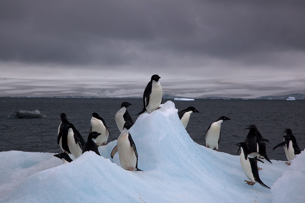
A few inhabitants of Antarctica are pictured here. Aside from the occasional scientist, humans don’t live in this icy landmass. So sometimes people don’t count it as a continent. (Photo: Jason Auch/CCBY2.0)
Most people agree with this one! It is one continent.
Antarctica was discovered in 1820 and was declared a continent a few decades later. But it took almost a century for it to appear on the maps consistently.
Yet, since humans do not live there, some people still discriminate against it and do not count it as a continent at all.
37 Old World Maps That Will Blow Your Mind
Australia/Oceania
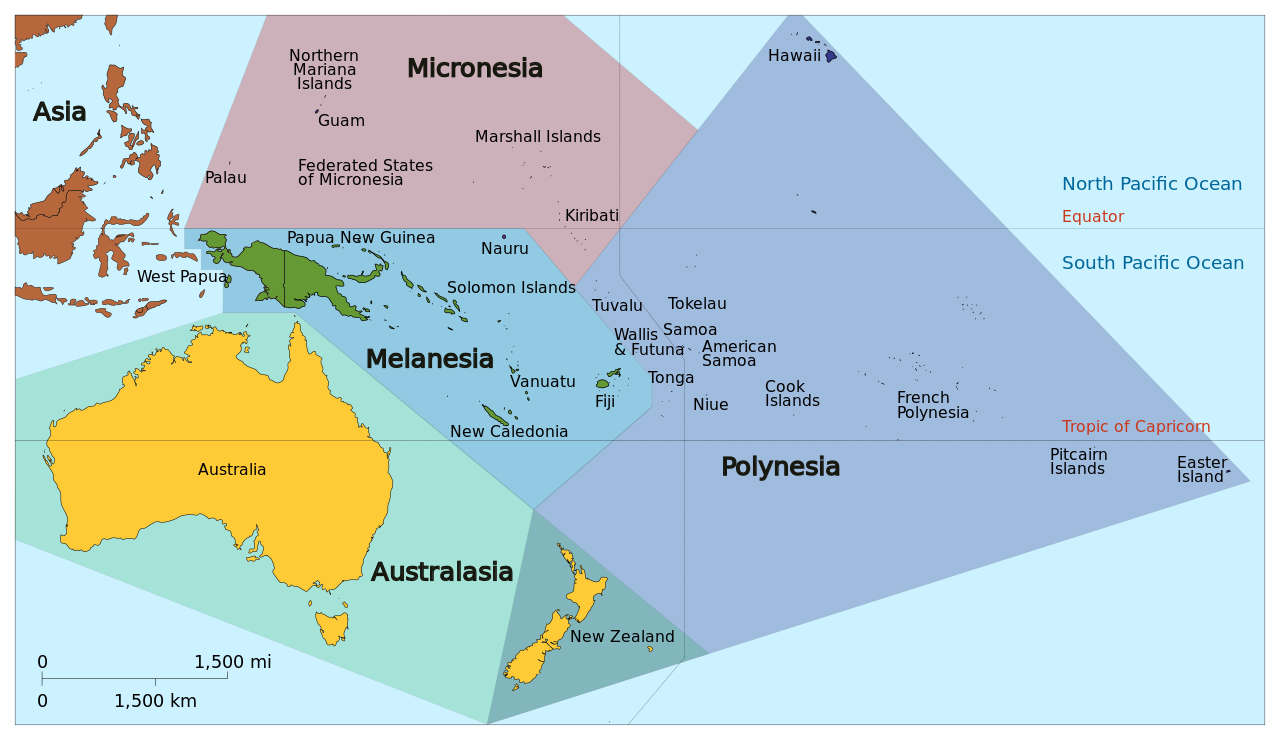
Australia, New Zealand, and all the other islands get grouped in Oceania. (Photo: Cruickshanks/CCBYSA3.0)
Another one that is more straightforward. Sort of.
Australia is an island-country, and almost everyone agrees it is also a continent.
Yet it was not always so. Australia was ‘discovered’ in the 17th century, but no one knew what to do with it continent-wise. Some ignored it, others called it an island or grouped it with Asia.
It was just in the 20th century that the idea of Australia as a continent began gaining adherents.
With 3.3 million mi2 (about 8.6 million km2) Australia is the smallest of the seven continents.
But it is much bigger than the next island in size: Greenland (836,000 mi2 / 2,160,000 km2). So Greenland is called an island, while Australia is now considered a continent.
Becoming Oceania
The thousands of small islands located next to Australia were eventually lumped together with it. And the name of the continent was changed to Oceania to reflect that it includes a lot of water and islands.
The concept of ‘Oceania’ is far from perfect. Its islands are spread in the Pacific Ocean, they do not have a shared history or culture, and they don’t even share tectonic plates.
Oceania doesn’t fit the (flimsy) concept of continent either, aka a large, independent landmass surrounded by water. It is almost the other way around: a large body of water with some (gorgeous) land sprinkled in there.
Something else worth mentioning is that not everybody agrees on the name of this continent. Some will vehemently call it Australia, while others, with equal conviction, will call it Australasia or Oceania. Your pick.
Read also: Find Out Which Big Cities Were Thriving 4,000 Years Ago
Are the tectonic plates the answer?

The red lines show the larger tectonic plates. Going by the plates, Asia is divided into a least 9 continents and the Americas into at least 8. (Image: Eric Gaba/CCBYSA3.0)
In the 20th century, some scientists came to believe that millions of years ago there had been just one huge continent: Pangaea.
A few decades later, other scientists introduced the concept of ‘tectonic plates.’ According to this, the globe is made up of plates that fit together, like a puzzle, but the pieces move. Sometimes they drift away from one another -which would explain how Pangaea split-, other times they crash into one another.
For a moment, there was light. Thanks to the plates, there seemed to be a scientific way to solve the debate on how many continents are there: just count the plates. But. Turns out there are more plates than anyone bargained for.
Plates come in all sizes, some are huge (over 7.7 million mi² / 20 million km2), while others are tiny (less than 386,000 mi² / 1 million km2). And there are more than 80 plates in total.
So take Asia. It is composed of many plates. The Arabian Peninsula and its surrounding areas lie on a separate plate from the rest of Asia. Anatolia has its own plate. So does India and some neighboring countries. Thailand and company, also have their own plate. Southern China, northeast China, and Japan each have their individual plate. And Siberia is on a separate plate. So Asia ends up divided into more than 9 continents! And that is just counting the larger plates.
The same happens to Africa and the Americas. They end up divided into many mini continents each.
California sits on a different plate than the rest of the US. Central America sits on three plates. And South America is divided into four plates. So, in total, the Americas are split into 8 large plates.
And the sneaky plates can show up where you least expect them. For example, the island-country of Iceland turns out to be sitting on two plates. As does New Zealand.
Meanwhile, part of Siberia is not in Asia but in North America. Take that, Cold War.
Plate Tectonics is a theory, that is, most people in the scientific community think it is accurate, but it is not an absolute proven truth.
The theory helps geologists, those who study the Earth, with their investigations. But when it comes to counting continents, it is not very useful, unless you want to end up with dozens of continents.
So to recap. You may find people that say there are 3, 4, 5, 6, or 7 continents. If they are going by the tectonic plates, they may consider there are more. One answer is not better or more accurate than the others.
The majority of people, though, will think there are between 5 and 7 continents.
How many continents do you count? Which ones?
More Articles


